GEFIS Gewerbeflächen-Informationssystem
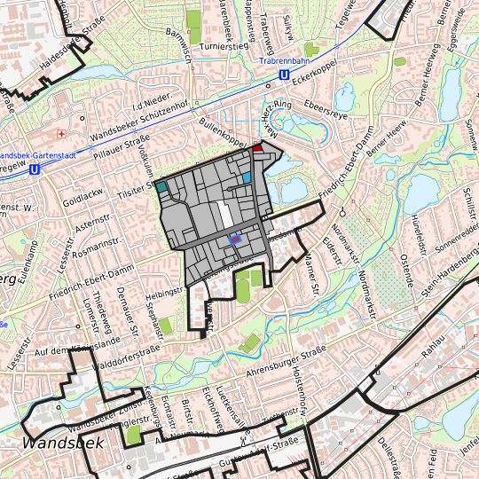
Friedrich-Ebert-Damm / Am Stadtrand (GI-FED-59) at Hamburg, Freie und Hansestadt Hamburg
Legend
Availabilities
Immediately
short term (2 years)
medium term (2-5 years)
long-term (> 5 years)
optional area (bindingly reserved)
occupational pension plan
not available
Brief description
Description of the parcel
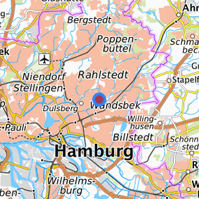
Friedrich-Ebert-Damm / Am Stadtrand
Municapility/city
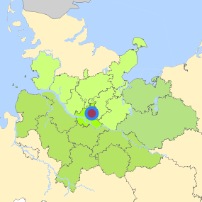
Hamburg
Parcel
Property size (m²)
751.84
Availability
immediately available
focus use
car park usage
further use
car park usage
Legal planning situation
Commercial space secured by planning permission
Yes
Building area according to land use plan
commercial building area
Existing planning law
§30 BauGB (qualified development plan)
Type and extent of building and land use
Specific type of structural use
GI
Development situation
fully accessible
24-hour operation
Yes
possible site occupancy ratio
Not fixed
possible floor area figure
Not fixed
possible number of full floors
Not fixed
possible height of building structures
Not fixed
cubic index
Not fixed
Exclusions/restrictions of land use
restrictions to mobilization
None
Infrastructur of site
broadband availability (at least 50 MBit/s)
Yes
quay edge
No
quay edge with sea-going vessel deep water
No
direct rail connection
No
electricity connection
Not specified
gas connection
Not specified
water connection
Not specified
wastewater connection
Not specified
Proprietary situation and marketing intention
proprietary situation
Not specified
Private
Detailed information about commercial zone
Gross surface area (ha)
76.7442
Sector focus
mixed sector structure
trade, maintenance and repair of motor vehicles
Type of location of commercial estate
classic commercial estate
location for crafts and small-scale trades
Transport accessibility
Motorway
A 24
4.2
km
Motorway
A 1
7.2
km
Motorway
A 255
10.1
km
Motorway
A 25
11.3
km
Motorway
A 252
11.4
km
Motorway
A 7
13.1
km
Motorway
A 253
15.8
km
Motorway
A 23
15.9
km
Motorway
A 21
23.5
km
Main road
Ring 2
1.9
km
Main road
B 5
5.1
km
Main road
B 75
5.3
km
International airport
Flughafen Hamburg
9.5
km
International airport
Flughafen Bremen
119.5
km
International airport
Flughafen Hannover
143.8
km
Regional airport
Flughafen Lübeck
52.6
km
Regional airport
Cuxhaven
120.9
km
Regional airport
Schwerin-Parchim
124.2
km
Commercial airfield
Uetersen/Heist
36.8
km
Commercial airfield
Hartenholm
44.5
km
Commercial airfield
Neumünster
63.8
km
Commercial airfield
Hungriger Wolf
68.0
km
Commercial airfield
Rotenburg (Wümme)
80.1
km
Port
Seehafen FHH
19.8
km
Port
Binnenhafen Geesthacht
29.4
km
Port
Binnenhafen Mölln
44.9
km
Port
Binnenhafen Lauenburg
45.0
km
Port
Port of Lübeck
54.4
km
Rail freight traffic
Emons Spedition GmbH
12.2
km
Rail freight traffic
Lübeck Nordlandkai (trimodal)
55.1
km
Rail freight traffic
Lübeck Konstinkai
56.5
km
Intermodal terminal
O'Swaldkai (FHH, trimodal)
10.5
km
Intermodal terminal
Süd-West Terminal (FHH, trimodal)
13.2
km
Intermodal terminal
DUSS Terminal Hamburg Billwerder (FHH)
14.4
km
Rail passenger transport
Trabrennbahn U
1.6
km
Rail passenger transport
Wandsbek-Gartenstadt U
1.8
km
Rail passenger transport
Straßburger Straße U
1.9
km
Rail passenger transport
Alter Teichweg U
2.4
km
Rail passenger transport
Hamburg-Tonndorf
2.7
km
Public transport
Hamburg Helbingtwiete
0.1
km
Public transport
Hamburg Am Stadtrand
0.4
km
Public transport
Hamburg Stephanstraße
0.6
km
Public transport
Hamburg Sylter Weg
0.7
km
Public transport
Hamburg Angerburger Straße
0.8
km
Availability of public transport
Not specified
Information about Hamburg
Inhabitants of the municipality
1,852,478
Trade tax rate
470
Property tax B
540
Contact
Stefan WieschebrockHamburg Invest
Bereichsleitung
Wexstr. 7
20355 Hamburg
Contact
Stefan WieschebrockHamburg Invest
Bereichsleitung
Wexstr. 7
20355 Hamburg